What's New
Bug fix...
Bug fix...
Size:
4.5 MB
Category:
Utilities
Utilities
OS:
iOS
iOS
Price:
$44.99
$44.99
Compatible:
iPhone iPad
iPhone iPad
Requirements:
Compatible with iPhone
Compatible with iPhone
Version:
1.0.2
1.0.2
Description - iGPSGIS II
.
please note location data depends on the gps receiver used. found in 1 reviews
organize data in topic layers showing colorful symbols and text labels. found in 1 reviews
record your track. found in 1 reviews
If you are iPhone and iPad owner,you now can download iGPSGIS II for $44.99 from Apple Store. The application is supporting English language. It weighs in at only 4.5 MB to download. The new iGPSGIS II app version 1.0.2 has been updated on 2014-11-16. The Apple Store includes a very useful feature that will check if your device and iOS version are both compatible with the app. Most iPhone and iPad are compatible. Here is the app`s compatibility information: Compatible with iPhone, iPod touch, and iPad.Requires iOS 4.3 or later.
More Info: Find more info about iGPSGIS II in CORVALLIS MICROTECHNOLOGY, INC.`s Official Website : http://icmtgis.wordpress.com
More Info: Find more info about iGPSGIS II in CORVALLIS MICROTECHNOLOGY, INC.`s Official Website : http://icmtgis.wordpress.com
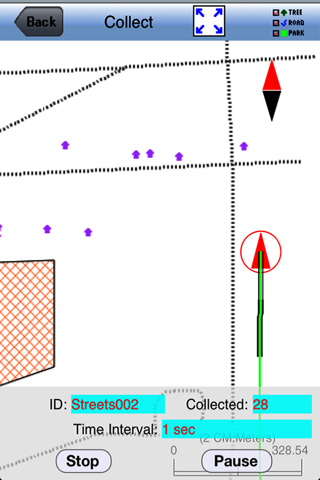
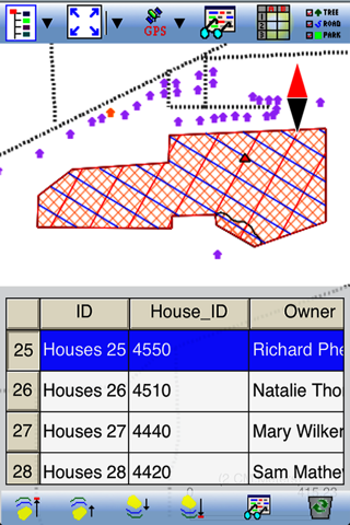
A powerful GPS/GIS mapping app to record Points, Lines and Areas with time and descriptions. When GPS is unavailable, you could digitize Features on top of a background map, or create points by entering angles ...
iGPSGISII is a high tech app for a low tech forester in a low tech consulting forestry firm The app is easy to use especially if you are already familiar with CMT s desktop PC GIS GPS software and Windows CE software Operating the features is more easily done with this app than on a Windows CE device that uses the CMT Cruise CE software Rather than firing up the large handheld device I can turn on my iPhone open the app and traverse stands and tracts track roads set points along boundaries and streams and any other number of useful activities Back in the office I can easily download the data to my desktop computer and my CMT CRUISE files This app has been a great aid to me in my mapping work The only limitation is that it uses a bundle of battery power I manage the battery power issue by turning off the GPS feature when I am not recording data and I carry a portable battery if I think battery power will be a problem on any particular job With the GPS on the app loads a current aerial photo of your location and saves it automatically for use as needed I am very happy with this app and with the customer support I received from CMT when I first used the app It Does the Job for Me Cynical Forester
It doesn t work with the new IOS upgrade Farmer Fresalva
Great GPS software Affordable program which can create point line or polygon features It would be great if I could create a template for data collection with drop downs It an affordable option which produces similar results to Trimble Terrasync without the post processing ability It s a great app for a tech savvy forester to have in the woods at all times to improve mapping efficiency Export shape files and email them to yourself to bring in data to your GIS software Great product going for some extra features Kyerdr
It doesnt work with the new IOS upgrade Farmer
Great GPS software Affordable program which can create point line or polygon features It would be great if I could create a template for data collection with drop downs It an affordable option which produces similar results to Trimble Terrasync without the post processing ability Its a great app for a tech savvy forester to have in the woods at all times to improve mapping efficiency Export shape files and email them to yourself to bring in data to your GIS software Great product going for some extra features
iGPSGISII is a high tech app for a low tech forester in a low tech consulting forestry firm The app is easy to use especially if you are already familiar with CMTs desktop PC GISGPS software and Windows CE software Operating the features is more easily done with this app than on a Windows CE device that uses the CMT Cruise CE software Rather than firing up the large handheld device I can turn on my iPhone open the app and traverse stands and tracts track roads set points along boundaries and streams and any other number of useful activities Back in the office I can easily download the data to my desktop computer and my CMT CRUISE files This app has been a great aid to me in my mapping work The only limitation is that it uses a bundle of battery power I manage the battery power issue by turning off the GPS feature when I am not recording data and I carry a portable battery if I think battery power will be a problem on any particular job With the GPS on the app loads a current aerial photo of your location and saves it automatically for use as needed I am very happy with this app and with the customer support I received from CMT when I first used the app It Does the Job for Me
By Kostas Gar.